
Date: 2026-03-04 Page is: DBtxt003.php txt00016673
Agriculture / Deforestation
Cocoa and other plantations ... also mining
Cocoa not main cause of deforestation in Ghana
Founder/CEO at TrueValueMetrics.org developing True Value Impact Accounting
Love this. In the early days of satellite technology I did some work on 'ground truthing'. I completely understand the difficulty there is in fully understanding what is going on though I embrace the idea that some information is way better than no information. I would like to see systematic analysis of both the big picture (country level) overview and the community level reality where real people are walking around.
Peter Burgess
Following the recently published report of the World Resources Institute (WRI) on global deforestation, we have been seeing a lot of discussions on the high deforestation numbers worldwide and in Ghana in particular.
Numerous media reports stated that Ghana is losing its rainforest faster than any other country in the world and that the 60% increase in deforestation during 2017-2018 is mainly associated with cocoa expansion.
We received a lot of questions related to the report. So we made a quick comparison of the WRI Global Forest Watch data, used in their report, with our own data for 2017-2018.
Our main takeaways:
Cocoa is only a minor driver of deforestation, major areas of change are more likely related to mining, logging, fire damage, and large scale agricultural expansion for crops other than cocoa;
- The reported sharp increase of deforestation in Ghana’s ‘primary forest’ appears to be correct, but WRI’s analysis did not take deforestation outside of these forest areas into account;
- The report does not take into account forest increase (reforestation) outside the primary forest areas.
Comparing data: what is forest?
To understand deforestation, it is important to first define what forests are. For the first time, the 2019 WRI report does not use the University of Maryland ‘tree cover’ layer of the year 2000 as a benchmark. This tree cover layer also includes agricultural tree crops such as cocoa, cashew, rubber, etc. in addition to natural forests. Using this layer would have led to mistakes when clearing of agricultural tree crops, for example for replanting, is flagged as deforestation. This time, however, WRI used the new University of Maryland ‘primary humid tropical forests map’ of year 2001 as a baseline to detect deforestation.
Importantly, the use of this map as a benchmark, excludes all agricultural tree crops. In Ghana, it is almost entirely limited to natural forest remaining in forest reserves and parks in the high forest zone.
Comparing data: what is deforestation?
So, we’re clear on the baseline used, but what about the deforestation related to it? To determine forest loss, WRI works with two different products from University of Maryland based on imagery from one satellite (Landsat):
- GFW GLAD Rapid Response alerts
- GFW Annual tree cover change, which is used for their latest report
- Satelligence’s weekly Rapid Response data
Analysis results
- The sharp (60%) increase in deforestation that WRI reported appears to be correct for Ghana. Satelligence and GFW Annual change product detected the same amount of change for 2018 (12,255 hectares);
- GFW’s Annual change product is released once a year. For the year 2018, the final product was released in April 2019. Satelligence’s system detects similar change acreage, but 4-16 months earlier than the GFW Annual change product;
- GFW’s GLAD system does not seem to work for the cocoa landscapes of West Africa. Only 800 out of 12,000 hectares i.e. only 6% of deforestation was detected;
- Our data and tentative analysis suggests that clearing for cocoa farming is not a leading cause of deforestation, contrary to what is widely reported in the media;
- The major areas of change are due to mining, selective logging, fire damage, and large scale agricultural expansion for crops other than cocoa.
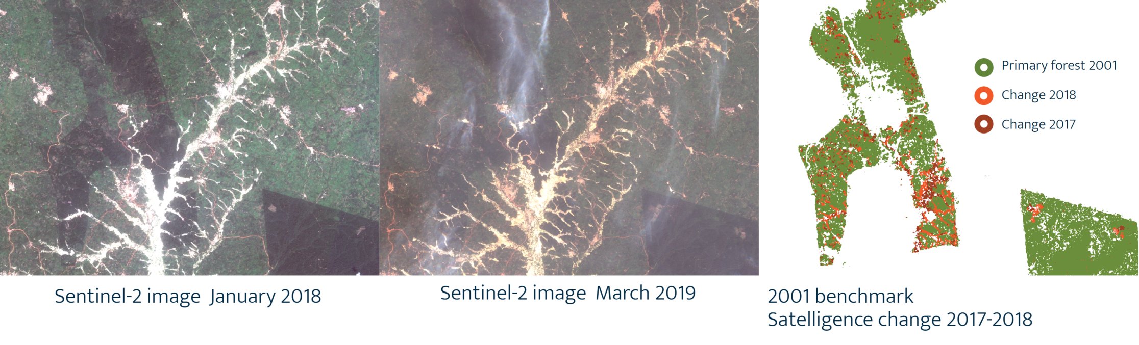
Figure: mining example Wassaba
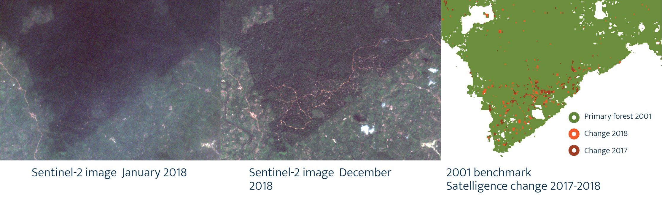
Figure: logging example Subuma
Figure: Large scale agriculture expansion, 10 times as large as the average size of cocoa fields, example Tano Ofin. It is highly unlikely these clearings are related to cocoa
Figure 3: Large scale agriculture expansion, 10 times as large as the average size of cocoa fields, example Tano Ofin. It is highly unlikely these clearings are related to cocoa
Conclusion: adding critical context by reporting on drivers of deforestation
Satelligence’s deforestation findings agree with WRI, but by using more frequent and higher detailed Sentinel satellite imagery we can add critical context by also reporting on the drivers of deforestation and providing fast response.
We conclude that over the past two years, clearing for cocoa farming is not the leading cause of primary forest clearing in Ghana.
Importantly, the WRI analysis did not focus on the detection of forest regrowth outside of primary forest areas, as was also stated by the Forestry Commission of Ghana. This means that the forest increase as a result of the government of Ghana’s hard work on its REDD+ and other interventions, which FC Ghana referred to in their response to the WRI report, is not accounted for.
Better monitoring for compliance
Although the GLAD system fails to provide timely information in the cocoa landscapes of West Africa, it is still a valuable addition that should not be dismissed and can be integrated in an overall global multi-sensor monitoring approach.
We agree with WRI’s emphasis on the need for improved data for compliance/full cocoa monitoring in their recent blog, and think the addition of Sentinel imagery, as we have shown here, can make the difference. We look forward to working on further verification and joint action with all stakeholders.
Contact me at dekker@satelligence.com for further details or to join our field verification work!