OVERVIEW
MANAGEMENT
PERFORMANCE
POSSIBILITIES
CAPITALS
ACTIVITIES
ACTORS
BURGESS
Communities, Society and Economy |
|
COMMENTARY |
|
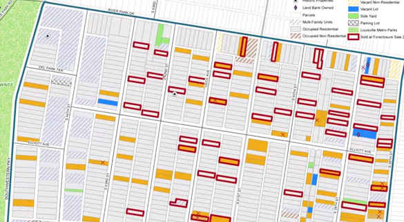
Mapping Neighborhoods To Create Neighborhood Opportunities A new project from Louisville is creating detailed maps of everything good and bad in a down-and-out neighborhood to discover exactly what the problems are and figure out how to make them better.
It’s a cliche of management that if you don’t measure something, you can’t manage it. But it’s true. And it applies as much to communities as it does to multinational corporations.
The video above is from a community action group in Louisville, Kentucky, called the Network Center for Community Change. The Network has been mapping neighborhoods to identify vacant lots, houses that need renovation, and more stable pieces of property. By doing so, it says the community can make decisions that better reflect local conditions, and needs. Vacant lots, which drag down the appearance of an area, and lead to crime and health issues, are a problem all over the country, especially since the foreclosure crisis. Mapping, though, is an increasingly popular way of strategizing about local problems, with major 'opportunity mapping' projects now underway in several cities. The Network started the Louisville initiative in November 2010 because it realized the official statistics about vacant properties were often inaccurate. 'The Metropolitan government tracks vacants at about 7,000 properties. What we’ve learned in the last 18 months is that they are off 26-30%, in both directions. Sometimes they way undercount it. Sometimes the vacants have been reoccupied,' says Jane Walsh, who heads the mapping project. 'The reason is they rely on citizen self-reporting to track the vacants. There is not even any accessible USPS data that we can get our hands on. We realized the only real way to know a neighborhood is on your feet, and by translating what you see to a map.' The group has tracked 3,600 properties so far, with plans to look at 3,600 more by the end of this year. Deputy director Jenny Jean Davidson says the data is useful when the group meets with politicians and quasi-government groups. 'It makes a big difference to be able to say 'you know, in this area, 23% of these houses are vacant’, and to be able to defend that number.' Walsh adds: 'There’s also value in the way everyone can look at the problem. When you start telling people 23% of units are vacant, they can go to the happy-place in their head, and quit listening. But when they look at it on a map, they process it in a different way.' BEN SCHILLER ... Ben Schiller is a staff writer for Co.Exist, and also contributes to the FT, and Yale e360. |
|
BEN SCHILLER ... Ben Schiller is a staff writer for Co.Exist, and also contributes to the FT, and Yale e360.
07/05/12 |
| The text being discussed is available at http://www.fastcoexist.com/1680137/mapping-neighborhoods-to-create-neighborhood-opportunities |
