
Date: 2024-04-29 Page is: DBtxt003.php txt00021016
US Social Trends
Housing
More Americans are moving into wildfire zones ... Megafire is colliding with America’s demand for cheaper housing near the great outdoors ...

The Woolsey Fire approaches homes in Malibu, California, on Nov. 9, 2018. Photographer: David McNew/Getty Images North America
Original article: https://www.bloomberg.com/graphics/2021-moves-into-fire-zones/
Burgess COMMENTARY
I learned about wildfires in the American West in the summer of 1960 when I visited Canada and the USA courtesy of the Cambridge University Canada Club. As students we were allowed to work in the summer break in Canada, and some of my student colleagues got work manning watchtowers in British Columbia to watch out for wildfires. The wildfire situation more than 60 years later is far bigger and much more dangerous both in terms of human life and property damage. This is caused by several factors and climate change is one of the main factors, but there are also others including the encroachment of residential construction into forest areas, inappropriate management of the forest and the undergrowth, and I believe the widespread degraded health of trees as a result of climate change.
Peter Burgess
Bloomberg Green
9:14 AM (8 hours ago) to me
Bloomberg
By Laura Bliss
Megafire is colliding with America’s demand for cheaper housing near the great outdoors, and the pandemic sharply accelerated that costly trend. In an investigation, Bloomberg CityLab found that during the first year of Covid-19, the number of U.S. households moving into areas with a recent wildfire history jumped 21% from the previous year. Meanwhile, areas without a recent wildfire history saw household moves decline by 15%.
My colleague Marie Patino and I analyzed U.S. change-of-address patterns from March 2020 to February 2021 to see how they fit into wildfire perimeters over the last 11 years. All over the country, we saw that the pandemic sped up an ongoing exodus into the “wildland urban interface,” or WUI — the edge between highly developed communities and the highly flammable wilderness — including in areas that have recently burned. In this map, the bigger the red dot, the greater the number of Covid-era household moves into census tracts that have been touched by wildfire since 2010.
“These are places that have burned and will burn again and despite that — despite the very visible indication of that in many cases — people are still moving,” said Kimiko Barrett, a researcher of community wildfire planning and policy at Headwaters Economics, a think tank.
These places include remote worker hotspots such as Boise, where new development is pushing further into the wilderness. It also includes Paradise, California, the city that was virtually obliterated by the 2018 Camp Fire, which killed 86 people. Experts thought that level of destruction would put a damper on migration trends into the WUI. But it didn’t, and Paradise is now drawing residents back: In the first year of Covid, some 650 more households moved into the area than in the year prior.
People have different motivations for these moves. One common thread is pure economics: Americans can get more space for less in communities far from denser urban centers.
The fact that few people seem to weigh fire risk very heavily is perhaps surprising. Part of it has to do with a lack of information such as wildfire risk disclosures for home sales, and a lack of regulation around where development can occur. But there’s also another simple explanation: “People tend to value the amenities of a home more than the risks it might carry.” said Jesse Keenan, a Tulane University professor of real estate.
America’s Covid-era flight towards the flammable wilderness is part of a much longer-term pattern of growth in the wildland urban interface. But as climate change makes wildfires more frequent, destructive and harder to predict, the cost of the country’s appetite for roomy housing near the wilderness will rise. In 2020, wildfires damaged nearly 17,700 structures, leaving insurers with $7 billion to $13 billion in claims in four of the most fire-prone states. This year that trend is expected to continue.
Check out our graphics and data in the full story, which brings the price of America’s exurban-pastoral ideal into full and fiery relief.
Some other reads…
A California moratorium guaranteeing insurance in wildfire-threatened areas will lapse Saturday, putting 347,000 homes in Pasadena and other Los Angeles foothills communities at the mercy of the market. Climate change has been rough on the world’s fifth-biggest economy. California, once synonymous with palm trees and Hollywood glamor, increasingly makes headlines for disastrous droughts and apocalyptic fires. Last year, wildfires torched nearly 4 million acres, and this year over 2 million; the Dixie and Caldor fires, two of the biggest, still aren’t entirely contained.
Firefighters battle the Caldor Fire near Lake Tahoe, in Meyers, Calif., on Aug. 31, 2021.
Photographer: David Odisho/Bloomberg
- Killer heat forces cities to adapt now or suffer.
- Tall buildings can rack up towering carbon emissions, too.
- Electric air-taxi revolution gathers steam in China, Japan.
----------------------------------------
Bloomberg the Company & Its Products Bloomberg Terminal Demo Request Bloomberg Anywhere Remote Login Bloomberg Customer Support
More Americans Are Moving Into Fire-Risky Areas ... In the first year of Covid, migration increased into places that have seen recent wildfires — even as blazes intensify.
By Laura Bliss and Marie Patino ... Graphics by Jackie Gu
September 24, 2021
Powerful winds, dense chaparral and a loose wire on a utility pole: That was the lethal combination that ignited more than 96,000 acres north of Los Angeles in November 2018. The Woolsey Fire destroyed 1,500 structures and killed three people as it spread across Thousand Oaks, Calabasas and Malibu, burning over the Santa Monica Mountains all the way to the Pacific’s edge.
For months, no homebuyer would come near, remembers Dave McLaughlin, who sells homes and lives in the area. The fire had left parts of it singed so badly they resembled a moonscape. When the first wave of coronavirus caused another dip in home sales, he thought he’d need a new line of work.
Then something odd happened: Demand for houses went into overdrive. By the end of 2020, McLaughlin had sold as much property in these wildfire-torched communities as any year in his career.
“Only a few clients in the last year or so have told me they don’t want to live here because the fire risk is too great,” he said from his own home on Malibou Lake, an affluent neighborhood where dozens of homes were destroyed in 2018 and which has seen surging sales in the past year. “Covid erased people’s wildfire fears.”
Wildfire Zones Grow in Popularity
Moves into areas with wildfire history went up, while others went down
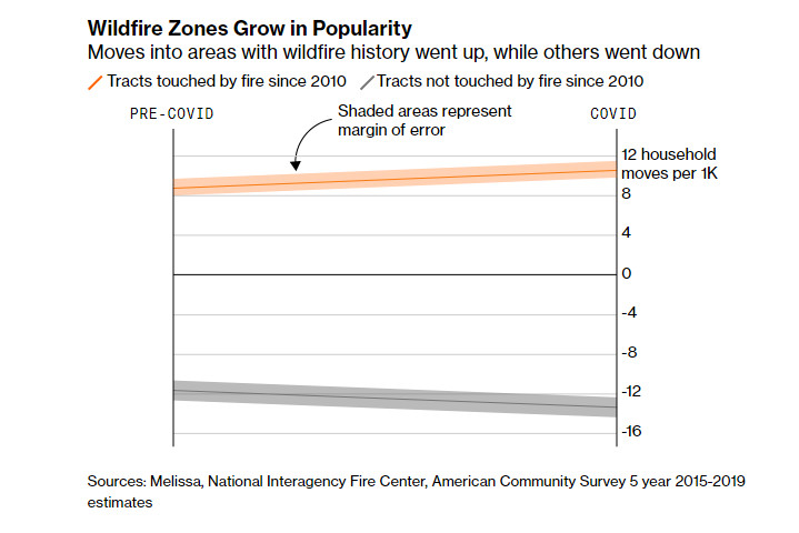
Sources: Melissa, National Interagency Fire Center, American Community Survey 5 year 2015-2019 estimates
That appears to be the trend across the U.S. Only 4.6% of U.S. households live in a census tract that’s been burnt by a wildfire since 2010. But their numbers have grown since the pandemic: Compared to the previous 12 months, the number of households that moved into areas with a recent history of wildfire climbed 21% between March 2020 to February 2021, according to a Bloomberg CityLab analysis of change-of-address data from Melissa, a global data intelligence and address analytics company, and wildfire burn areas from the National Interagency Fire Center.
2021 FIRES

CENSUS TRACTS TOUCHED BY FIRE SINCE 2010

1,000 NET MOVES
CENSUS TRACTS TOUCHED BY FIRE SINCE 2010
100
Here is the footprint of wildfires so far in 2021...
...and the land burned by wildfires since 2010.

The census tracts where these fires happened...
...saw more people moving in since the start of the pandemic. The bigger the pink bubble, the greater the number of moves.
The census tracts where these fires happened

Sources: National Interagency Fire center, Census Bureau, Melissa
Note: Some Census tracts touched by fire since 2010 are so small to be invisible on these maps
Sources: National Interagency Fire center, Census Bureau, Melissa
Not all of these places saw severe damage from the flames. Still, the accelerated migration into flammable territory during the pandemic contrasts with what happened in areas that haven’t burned since 2010, which saw a 15% decline in household moves during the first year of Covid-19 compared to the previous year. Propelled by affordability pressures, a desire for space amplified by pandemic life, and in some instances a misplaced sense of security, it is part of a much longer-term trend: More people are living within the wildland-urban interface, or “WUI” — the edge between highly developed communities and highly flammable mountains and forests. That raises the level of risk to life and property, as well as the cost, particularly as wildfires become more destructive, frequent and hard to predict.
“People tend to underestimate their fire risk,” said Jesse Keenan, a professor of real estate at Tulane University who studies the effects of climate change on the built environment. “We’re starting to see consistently that fire is burning in ways we haven’t before.”

In this aerial photo, a burned neighborhood is seen in Paradise, California on November 15, 2018. Photographer: Josh Edelson / AFP via Getty Images
Dried-out forests, hotter temperatures and more ferocious wind patterns are combining to break burn records year after year. In 2020 alone, nearly 17,700 structures were destroyed or damaged in wildfires across the U.S., saddling insurers with an estimated $7 billion to $13 billion in claims in just four of the most fire-prone states. By far the majority of that wreckage was in California, which has seen 8 of the 10 largest fires in its history in the last four years. There, 2020 set the record for most acreage consumed as well as the most the state has spent on emergency fire suppression. That trend of costly devastation is expected to continue into 2021, as the Dixie Fire, the single largest in California history, continues to burn north of Sacramento.
The financial impacts are largely weathered by local communities. Less than 10% of the total expenses incurred by wildfires are related to suppression, which is generally paid for by state and federal government, according to a report by Headwaters Economics, a think tank. The rest of the cost is from long-term, local rebuilding efforts such as road repairs, watershed restoration and home reconstruction. “All the costs, on all fronts, are going up,” said Kimiko Barrett, who researches community wildfire planning and policy at Headwaters Economics.
California’s Wildfire Footprint


By early 2021, moves to the Paradise area spiked 120% as many people returned.
Note: Urban areas on map correspond with Census definition. Sources: National Interagency Fire Center retrieved September 6 2021, Census Bureau, Microsoft building footprints
Yet the movement trends are seen throughout the West, where significant portions of the population already live in fire-prone areas. In California, 12% of households live in an area that has seen wildfire since 2010. That share is 38% in Idaho, and 19% in Utah. These were also the top three states with the highest number of moves last year into tracts recently touched by fire.
“These are places that have burned and will burn again and despite that -— despite the very visible indication of that in many cases — people are still moving,” Barrett said.
Motivations vary, with many people choosing to live in areas with forested backyards and access to the outdoors, with more square footage for their dollar. In other cases, people are being pushed out of cities due to housing constraints and have few choices but to settle in further-out areas.
A sample of fire-touched tracts that saw some of the biggest increases in new arrivals is a window into that spectrum. While data available from Melissa is based on U.S. Postal Service changes of address and does not include all U.S. moves, it is comprehensive enough to capture trends. The appetite for housing in these vulnerable areas can also be seen in jumps in home prices.
In Butte County, California, the Camp Fire killed 86 people and virtually leveled the town of Paradise in 2018. That disaster has been held up as an early example of what climate change had in store. And many experts expected it to change the trajectory of WUI settlement.
TK TK TK TK Paradise in May 2018, before the Camp fire. TK TK TK TK Paradise in Dec. 2018, several weeks after the Camp fire. TK TK TK TK Paradise in May 2021. Source: Google Earth / Maxar Technologies
But in the first year of the pandemic, some 650 more households moved into the Paradise area than in the year prior, when household numbers plummeted following the fire. Many of them were fire victims who rebuilt or resettled there after living away, partly because it was far more affordable than other nearby areas. In surrounding Butte County — which includes the city of Chico, where many Camp Fire refugees landed — housing demand has also grown.
“Moving to Chico was an option, but the housing market was so hot there — we didn’t want to pay for something that we didn’t really want,” said Alana Imrie, a fisheries biologist who lost her Paradise home in the Camp fire but moved back in November 2020. For two years, she and her husband and two teenage daughters bounced between short-term rentals via friends before moving into a home rebuilt on the same lot that had burned.
In other parts of the U.S., many of the hottest housing markets are in suburbs and exurbs with a recent history of wildfire. On the outskirts of the Provo-Orem area, Saratoga Springs, Utah, saw 1,160 more households moving in than out during the first year of the pandemic, according to data provided by Melissa. That is despite the June 2020 blaze that forced the evacuation of roughly 13,000 residents and another major wildfire season in 2012. Officials warned residents once again this summer to use extreme caution with fireworks and other flammable materials.
But wildfire risk wasn’t a factor for Charlotte Peterson, a nutritional therapy practitioner who moved to the city with her husband and two small children in January 2021 in order to be closer to family. The real estate agent who sold them their new house didn’t mention last summer’s fire, she said, though she had been aware of it: An aunt and uncle had been in the evacuation zone. But only in Saratoga Springs could they get an offer on a house accepted. “We looked all over the surrounding area, and everywhere, houses were going so quickly,” she said. “Then we found this one, and there wasn’t a fight to go get it.”
Then there were people who flocked to the Boise, Idaho, area, one of the most touted destinations for people fleeing higher-cost housing markets in Oregon and California. Tracts in Ada County, where the Table Rock fire burned nearly 2,500 acres and destroyed one home in 2016, saw 1,675 more households move in than out during the first year of the pandemic.
Home Values in Ada County Increased More Than National Averages Percentage change since February 2019 Mid-size metros: national average
Large metros: national average COVID-19 PANDEMIC 60% 40 20 0 -20 April 2019 April 2020 April 2021 Satellite image showing suburban developments next to a hill A satellite image of the Boise neighborhood of Barber Valley in July 2010. Satellite image showing the same area with the outline of a 2016 fire covering most of the hill By January 2017, development encroaches closer to the footprint of a 2016 fire.
Satellite image showing the same area in 2020 with even more buildings and planned developments than before
This May 2020 image shows how new development plans continue to extend along the perimeter of the fire zone.
Sources: Zillow, CDC 2013 NCHS Urban-Rural Classification Scheme for Counties, ZHVI index, Google Earth / Maxar Technologies, National Interagency Fire Center, Barber Valley Neighborhood Association
Officials have warned that almost nowhere in Idaho should be considered low risk for ignition, with a history of some of the country’s largest wildfires in terms of acreage. Historically, sparse population has meant those blazes have posed relatively little risk to humans. But Idaho was the second fastest-growing state in the latest U.S. census, with much of the new development pushing deeper into that flammable wilderness. Many newcomers aren’t familiar with the ignition risks, said Alicia Ralston, a real estate agent in Ada County, where home prices have climbed 53% since March 2020, according to the Zillow Home Value Index.
Empty streets in front of a modern Silicon Valley office space.
A wildfire fire burns near the Table Rock cross in Boise, Idaho, in the early morning hours of Thursday, June 30, 2016. Photographer: Joe Jaszewski/Idaho Statesman/Tribune News Service via Getty Images
“We always bring the conversation up, and a lot of people look at us like it’s the first time they’ve thought about it,” she said. “Some will follow up with thoughtful questions, and others move right to asking how many garages there are or if it has a six-burner stove.”
The overall trend into these areas is not altogether surprising. Living on the edge of wilderness has been held up as an ideal in American culture since the country’s founding, while the entrenched forces that have kept new housing construction in major cities at historic lows have meanwhile driven new supply further into the boonies. The pandemic put new premiums on having home offices and roomy backyards, but it is part of a much longer rush toward the exurbs as Americans seek more living space at lower costs. A 2018 study led by Volker C. Radeloff at the University of Wisconsin, Madison found that more than one-third of new homes built between 1990 and 2010 were in the wildland-urban interface. Cheap mortgage rates have meanwhile made these markets more accessible.
“Covid didn’t really cause this. It just accelerated something that was well in the works,” said Keenan, the Tulane professor. “People tend to value the amenities of a home more than the risks it might carry.”
That fact that many people don’t weigh wildfire risk very heavily in their housing decisions is partly due to imperfect information, said Keenan and Barrett: For example, most states do not require sellers to disclose wildfire risk to new buyers, and tools for assessing that risk are still in their nascency. California has strengthened building codes in response to wildfires, requiring the use of ignition-resistant materials and defensible space around new homes. But such regulations are still the exception on a national level, and it’s still possible to get insurance policies in most high-risk areas — even in California, where insurers are currently banned from denying coverage in wildfire-prone communities.
What’s more, memories are short, and people sometimes assume that because an area has already burned, it won’t burn again for a long time.
But that may not always be the case. Eight months after Imrie and her family moved into their new home in Paradise, the Dixie Fire ignited — starting in nearly the same place as the Camp Fire had. While the town was left unscathed, the close flames and smoke meant Imrie kept her car loaded up and ready to evacuate for a week straight. Reliving the trauma of 2018 triggered conversations with her husband about moving somewhere else. But with family on the West coast, she said, it’s hard to know where it would be safer that they could also afford. “We’re all over the place with it,” she said. “It’s hard, because climate change is real and our environment is changing.”
Editors: Nicole Flatow, Brad Skillman and Mira Rojanasakul
With assistance from Andre Tartar, Alexander McIntyre, Aaron Kessler and David Ingold
Methodology
Migration data was provided by Melissa, and is an enriched version of the U.S. Postal Service change of addresses dataset. The data made available to Bloomberg CityLab is as detailed as the census tract level, and does not contain all the moves that have occured in the U.S. (those having moved without declaring so aren’t recorded, and some might redirect their mail to PO boxes).
Moving numbers were provided for 72,769 census tracts (based on 2010 geographies), for the first year of Covid-19 (March 2020-February 2021), and the year prior (March 2019-February 2020). We calculated net moves for each of those tracts as moves into the tract minus moves out of the tract. All numbers are household moves. The dataset may contain PO boxes, but all tracts in which the number of net moves exceeded the total population were excluded. We included an additional 1,249 tracts absent from the data: They appear in our calculations as having 0 net moves. 722 tracts in the data provided had an unknown number of moves either prior to or during the pandemic, and the unknown number was treated as being 0.
Northern Marianas, Virgin Islands and Guam are not included in our calculations.
We define tracts touched by fire as the ones in which a fire has occurred since 2010, and burned a portion of its area. Fire perimeters since 2021 come from the National Interagency Fire Center. The data was retrieved on Sept. 6, and as the Dixie fire has been raging through California, our maps do not reflect events from the last three weeks. To find the tracts that had been touched by fire since 2010, we overlaid census tracts and fire perimeters, after dissolving and simplifying the fire perimeters and preventing shape removal with a Douglas Peucker algorithm. Some tracts (notably in the northeast), have had less than 1% of their surface area burnt. They were included in the analysis, and excluding them does not substantially change the findings.
All census numbers used are from the ACS 5-year estimates 2015-2019 table B11001. As we calculated per-1,000 household numbers at the census tract level, we included a confidence interval where possible. Melissa’s data does not come with a margin of error as it is a raw count, so net moves don’t have a confidence interval.
-------------------------------------
Tokyo Summer Olympics Medal Tracker: Medal Count by Country July 21, 2021
Highest Paid U.S. CEOs: Top Salaries in 2020 Aug. 4, 2021
US Economic Recovery: Black, Hispanic Groups See High Unemployment Rates Sept. 22, 2021
MacKenzie Scott Net Worth 2021: Here's How the Billionaire Is Giving Wealth Away Aug. 12, 2021
How Extreme Heat Will Force Cities to Adapt Aug. 31, 2021
Mapping the Past and Future of Urban Highways July 28, 2021
Students are seen in a Financial Management course at the Beatty Center for the School of Business on campus at College of Charleston in Charleston, South Carolina, U.S., on Monday, September 13, 2021.
Best Business Schools & MBA Programs 2021-22 Sept. 15, 2021
German Election 2021: Live Results Sept. 25, 2021
Terms of Service Do Not Sell My Info (California) Trademarks Privacy Policy ©2021 Bloomberg L.P. All Rights Reserved