
OVERVIEW
MANAGEMENT
PERFORMANCE
POSSIBILITIES
CAPITALS
ACTIVITIES
ACTORS
BURGESS
|
NATURAL CAPITAL ... WATER
Running Toward Empty? About the Colorado River and the allocation of its water to various competing places and interests 
Sunset on the Colorado River. The river is the lifeblood of the Southwest, providing water for nearly 30 million people. Original article: https://www.climatecentral.org/news/running-toward-empty Peter Burgess COMMENTARY As a country, the United States has a quite low population density. In spite of this, many parts of the country have a dangerous shortage of water. This is a growing problem in the West of the United States where the provisioning of water depends on the watershed of the Colorado River. This is some of the story. Peter Burgess | ||
|
Running Toward Empty?
Written by Tom Yulsman and Brendon Bosworth It may not be too much of an exaggeration to say that for many people in the drought-plagued West, the status of mountain snowpack is as eagerly awaited as the stats from college sports matches. That’s because much more than team pride is on the line. After all, there is skiing to be done, and when the snow melts and the water tumbles into streams every spring, many Westerners like to kayak or tube in it, and others to cast their fly lines into the icy, trout-filled waters. On a more practical level, water plummeting from mountains to plains is used to generate renewable electricity. And of course, more than anything else, Westerners drink it and use it to turn their sere landscapes green. None of the river basins in the West garner more attention than the Colorado. The waterways of the basin drain nearly 246,000 square miles of territory. They also serve nearly 30 million people in seven states and Mexico, including residents of Los Angeles, Phoenix, Tucson, Las Vegas, Denver, and Albuquerque, and irrigate more than three million acres of crops and pasture. The Colorado River quite literally is the lifeblood of this region. But now, an emerging new reality in the river basin has both scientists and water mangers concerned about the future. It is unfolding thanks to ever-increasing demand for the Colorado’s water, combined with drought — which may become more frequent and severe in the future thanks to climate change from human activities. And so without long-term changes to water use, the challenge of matching supply and demand in an increasingly parched region will only grow more acute. This is the subject of a two-part feature here at Climate Central. In this first story, we examine what’s happening now in the Colorado River Basin. We'll also look at the impact of a continuing multi-year drought on the region, and what it means for those 30 million users of Colorado River Basin water. And in part two, we explore what the future may bring. * * * * * In recent weeks, water managers, skiers and farmers, if not city folk, from California all the way to Colorado were breathing a little easier with the news that storms have significantly boosted both mountain snowpack and the water supply outlook in the Colorado River Basin. As of January 6, the average snow water equivalent for most of the basin was at 141 percent of the long-term average. (Snow water equivalent is the depth of the water you’d collect if you melted a given amount of snow instantaneously). This is the very best start to the year since 1997, according to the Colorado Basin River Forecast Center. Most importantly, it is a dramatic — but not necessarily permanent — turn-around from the situation as it looked last October. At that point, 11 long years of debilitating drought in the region, combined with growing demand on the river, had helped drain Lake Mead, the giant reservoir on the lower Colorado near Las Vegas, to a record low level. (For the current level of Lake Mead, click here.) Now, with early winter storms, the lake level has come up by a foot. Water managers view this as a hopeful sign, but one that does not by itself indicate a more durable turnaround. Lake Powell is a man-made reservoir on the Colorado River, straddling the border between Utah and Arizona. It is the second largest man-made reservoir in the United States behind Lake Mead. Credit: Wolfgang Staudt/flickr Water managers are scraping for every inch they can get to keep the reservoir’s surface higher than 1,075 feet above sea level. Should it fall below that marker, the federal government would be forced to declare a shortage, requiring Arizona and Nevada to cut back on their use of Colorado River water. But what about all that early winter precipitation that has arrested the fall in Lake Mead’s level, and which has also been raising the level of the other giant reservoir on the Colorado, Lake Powell? That moisture has certainly been welcomed by water managers. But does it herald an end to the multi-year drought? Conditions at the beginning of the winter offer no guarantees for how much water will be available in the spring. For example, last year also looked very good, with the snow water equivalent in the upper Colorado River Basin considerably higher than average. Yet by the end of the “water year” on September 30, 2010, total precipitation accumulated in the basin for the previous 12 months was just 84 percent of average. Right now, the Bureau of Reclamation is predicting that when melt water from mountain snowpack runs off during the warmer months ahead, and is combined with summer precipitation, the Colorado's flow into Lake Powell will total 110 percent of average. But as last year's experience suggests, the flow could also turn out to be lower than expected — as low as about 75 percent of average, according to the bureau — depending on weather conditions. And even if flows in the Colorado turn out to be about 110 of normal, that's not nearly enough to erase the impact of 11 years of drought. So for now, despite early and deep snows, the Bureau of Reclamation says the Colorado River Basin is still considered to be in long-term drought. This highlights an immutable fact of life here in the West: What nature provides in one month she can easily take away a few months later, if not sooner. And in this region, the taking away is so common as to be just as “normal” as the giving. Even without any drying that could occur from climate change over the next few decades, the fact is that people have been taking more water from the river basin than actually flows there on average. Without action to change that imbalance, shortages will be inevitable — particularly in what are known as the “lower basin” states: California, Nevada and Arizona. “The large amounts of snow early this winter may put off the day of reckoning for the lower basin,” says Brad Udall, director of the Western Water Assessment at the University of Colorado. But the long-term picture of increasing shortages “is not going to change based on one year of runoff.” The Colorado River Delta as seen from space. Drainage from irrigation and urban sprawl now prevent the river from reaching its final destination. Credit: NASA/GSFC/MITI/ERSDAC/JAROS In 1922, the states of the Colorado River Basin signed the Colorado River Compact. The agreement divided the waters of the Colorado, with the upper basin states of Colorado, Utah, New Mexico and Wyoming — where most of the water originates — to receive an entitlement of 7.5 million acre-feet (MAF) each year. (An acre-foot is the amount of water required to cover one acre of land to a depth of one foot). The agreement also mandated that the upper basin states deliver 7.5 MAF each year to the lower basin states. How can the upper basin states deliver the required amount of water to the lower basin during times of drought, without curtailing their own use? That is precisely why the Glen Canyon Dam was constructed. It impounds Colorado River water in the massive Lake Powell. In essence, the reservoir is a bank account that the upper basin states can draw on to send the required amount of water to California, Nevada and Arizona. During the drought that began in 2000, flows on the Colorado dropped by about 20 percent, according to Udall. Yet the upper basin states were able to cover their obligations thanks to releases from their bank account, Lake Powell. As a result, “savings” of water in the Lake Powell account have decreased from a high of 97 percent of capacity in 1999 to 60 percent as of last December. As the water has dropped, it has left behind a white bathtub ring around the red sandstone cliffs. (NASA’s Earth Observatory has an excellent series of photos, and an animation, showing how the lake level has dropped). Supply vs. Demand So if the system has been working as planned to assure water deliveries to the lower basin states, why did their giant reservoir on the river — Lake Mead — drop so precipitously prior to the small increase in rain and snow this winter? To understand the answer to that question, let’s take a look at a little additional history — and some numbers. In addition to the 7.5 MAF of water each to the upper and lower basins, the Colorado Compact also allocated 1.5 MAF to Mexico to meet the terms of a treaty, for a total allocation to the different users of 16.5 MAF of water. At the time the compact was negotiated, this must have seemed like a good bet, since the river was then averaging around 20 MAF per year. But it turns out that things were abnormally wet in the era when the compact was negotiated. In fact, from 1906 up to 1930, the 10-year average flows on the river were higher than during any other part of the record (with the exception of a brief spike in the mid-1980s). This means that through most of the years after the compact was signed, flows in the river were about 1.5 MAF less than what the compact assumed would be available. And lately, they’ve been even lower. Yet Westerners have continued to ski, kayak, fish, drink, and water their lawns and pastures. That’s because actual use of Colorado River water was considerably lower than the flow in the river. In other words, there was still plenty of water to go around, even during times of shortage. Credit: Russell Freedman for Climate Central. Data: Bureau of Reclamation. But starting in 2002, this picture changed. In that year, total demand outstripped the total amount of water actually flowing in the river. “During this drought the curves have finally crossed,” says Terrance Fulp, deputy regional director of the Bureau of Reclamation’s Lower Colorado Region. “Obviously, no matter how much storage you have in the system, you’re not overly confident in your sustainability if demand continually outstrips supply.” Recent research has revealed another factor that’s robbing water from the system: dust blown from nearby Southwestern deserts. The study, by researchers from NASA’s Jet Propulsion Laboratory and the University of Colorado at Boulder’s Cooperative Institute for Research in Environmental Sciences, finds that dust particles have caused the peak in spring runoff on the Colorado just below Lake Powell to occur three weeks prematurely, costing the Colorado River an astonishing five percent of its annual flow. Traditionally, Lake Mead has been topped off with extra water from Lake Powell, unused by the upper basin states. But during the recent drought, water managers decided to provide only normal deliveries from the Lake Powell bank account. For Lake Mead, this has meant users have been removing more water than has been flowing in. And so inevitably, Lake Mead has dropped, from almost full in 2000 to about 42 percent full in mid-2010. “What you’re really seeing here is a combination of drought and an overuse problem amongst the three lower basin states of California, Nevada and Arizona,” Udall says. “That overuse problem historically has been covered up by a little extra water that flows down from Colorado and the upper basin states. But over the last 11 years, with the most serious drought on record, that water hasn’t been there, and so the overuse problem has become readily apparent.” Will wetter conditions return to turn the situation around? Part two of this series addresses that question. Along the way, we’ll examine what has happened in this region in the past — as it is a guide to what could happen in the future. We’ll also look at the projected impact of human-caused climate change, and how scientists and water managers are trying to cope with the two, mutually exclusive trends in this region: increasing aridity and increasing demands for water. Brendon Bosworth is a masters student at the University of Colorado, Boulder. His advisor, Tom Yulsman, is co-director of the Center for Environmental Journalism and a frequent contributor to Climate Central. Comments By Lou Grinzo on January 18th, 2011 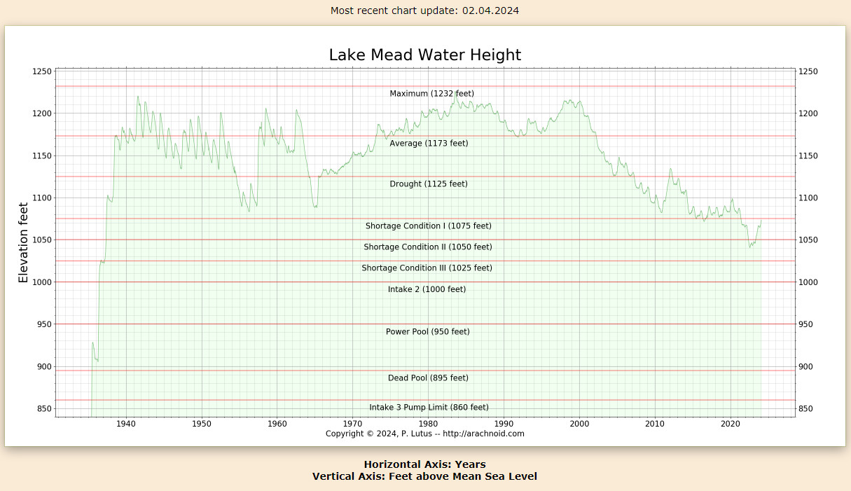
Graph of Lake Mead level: http://www.arachnoid.com/NaturalResources/ By Francis on January 19th, 2011 I’m no expert on the Law of the River; that’s a pretty short list. But I have read most of the relevant documents and I am licensed to practice law in California. That said, a few points: Many California water lawyers would disagree with the way you lay out the priority for water between the Upper Basin and Lower Basin states. They would say that the Upper Basin states first are obliged to deliver 7.5 million acre feet per year (mafy) to the Lower Basin states (on a 10-year rolling average), and only after that obligation is completed do they have a right to take the next 7.5 mafy. After all, the IID farmers were using substantial amounts of River water when Colorado and Nevada were taking next to nothing. Point two: Brad Udall is an expert on the River, but he appears a little biased in favor of his state. “Overuse” is a value-laden term. Last I checked, California was living within its 4.4 mafy limit. (Yes, I’m aware that litigation over the QSA is ongoing, but that mostly has to do with Salton Sea mitigation.) Who, precisely, is taking in excess of allocation? Final point: Western water law requires users to put water to beneficial use. California has one of the largest economies in the world, and the movement of enormous volumes of water is critical to the economy—from agriculture in Imperial County to the commercial, industrial and residential uses of Los Angeles and San Diego. I’ll compare MWD’s beneficial use of Colorado River water (in terms of economic activity) against that of any other state on the River. By John Fleck (87110) on January 19th, 2011 Francis - If I may, from my perch here in the upper basin, defend Brad’s “overuse” argument…. Here’s the arithmetic, courtesy USBR data: Total average annual Lake Mead inflow: 9 million acre feet (compact-required annual Lee Ferry delivery plus inflows between Powell and Mead). Total average annual Mead outflow: 9.6 maf (CA, AZ and NV’s 7.5 maf, plus Mexico’s water, plus system losses) Mead evaporation loss: 0.6 maf Annual deficit: 1.2 maf If by “overuse” we mean “using more than the law allocates”, then no, the lower basin states are not overusing. They’re living within their allotted 7.5 maf. But in using their full 7.5 maf, they’ve been using more than nature and required compact deliveries provide each year. This problem has been papered over for decades both because Arizona until the ‘90s was not taking its share, and by ongoing deliveries past Lee Ferry in excess of delivery requirements. Now that Arizona’s taking its full share, and a drought has reduced upper basin deliveries to the minimum legal requirement over the past decade, the problem has been laid bare. By Bob Walsh (Henderson NV 89012) on January 24th, 2011 Please note that, contrary to what this article states, the Colorado Compact did not allocate any Colorado River water to Mexico to meet the terms of a treaty. The 1922 Compact did not allocate any water to Mexico, period. That allocation occurred as the result of a treaty between Mexico and the United States that was signed in 1944—or twenty-two years after the Compact was signed. By Leroy Hawkins (York/Pa/17401) on September 15th, 2012 The problem of outdated law is pervasive in many areas ofthe law. Why we continue to allow this is ” we tend to sit on our laurels because we think to much of our solutions and let them go on too long without review. My thought on the general issue of muti-state agreements is that when issues of water usage come up all share the pain and take equall percentage losses for years that the flows are reduced. And, please do not wait fifty years for a review/response.
| The text being discussed is available at | and |